|
OBSERVING THE
SURFACE
CIRCULATION ALONG THE SOUTH-CENTRAL CALIFORNIA COAST USING HIGH
FREQUENCY RADAR: CONSEQUENCES FOR LARVAL AND POLLUTANT DISPERSAL
Principal Investigators: Libe Washburn
(UCSB), and
Steven Gaines (UCSB)
Summary of Research
 Four high frequency (HF) radars were operating in
the Santa Barbara Channel for use in observing the surface circulation
patterns in the region. In collaboration with Dr. Carter Ohlmann we
conducted experiments which combine observations from drifters and HF
radars to assess the accuracy of current velocities derived from HF
radar. Four high frequency (HF) radars were operating in
the Santa Barbara Channel for use in observing the surface circulation
patterns in the region. In collaboration with Dr. Carter Ohlmann we
conducted experiments which combine observations from drifters and HF
radars to assess the accuracy of current velocities derived from HF
radar.
Edwin Beckenbach's (Ph.D. June 2004)
dissertation work was largely funded by this and a previous MMS
research grant. The primary focus of his dissertation research is
the surface circulation dynamics of the western Santa Barbara
Channel. This work builds significantly on oceanographic research
in the region conducted by the Center for Coastal Studies at the
Scripps Institution of oceanography. A paper was published
earlier this year (Beckenbach and Washburn, 2004)
which describes a propagating wave-like phenomenon resembling a type of
coastal trapped wave. Another focus of Beckenbach’s dissertation
is the relationship between wind forcing and the two-dimensional
surface circulation in the western Channel.
A second HF radar system was deployed in the eastern
Santa Barbara Channel in May to September 2004. The first
radar system in the eastern Channel was installed in 2003 at
Reliant Energy’s Mandalay generating station. In addition to
providing important data on the circulation of the eastern Channel,
observations from this radar supported a juvenile fish
recruitment study also funded by MMS (Milton Love, principal
investigator).
2. Surface Circulation in the Santa Barbara Channel
As described by (Beckenbach and
Washburn, 2004),
we used a three-year time series of HF radar-derived currents to
describe propagating rotary wave-like features in the western Santa
Barbara Channel. This was a new discovery and our analysis
suggested that the features are topographic Rossby modes, a resonance
phenomenon setup by large scale coastal trapped waves which excite
resonant oscillatory flows over the Santa Barbara Basin.
Reviewers of our paper commented that this is the best oceanographic
evidence to date documenting the existence these modes.
Another focus of our research is
the Channel’s two-dimensional flow structure and its relationship to
wind forcing. We find that the long term mean circulation is
characterized by convergence over the Santa Barbara Basin, opposite the
flow pattern predicted by the wind field (Fig. 1). This is
important because it indicates the convergence is not wind
driven. On shorter time scales a clear relationship between wind
forcing and the surface flow is evident. Conditional averaging of
the surface flow based on modes of the wind field shows that consistent
circulation states correspond to the wind modes. This analysis
also supports model predictions of (Oey et al., 2001)
which relate the strength of the characteristic cyclonic flow to the
along-channel wind gradient.
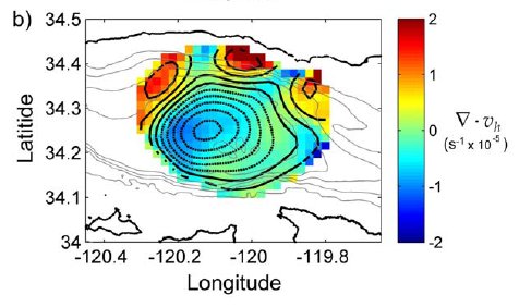
Figure 1. Four-year mean (1998-2001) surface divergence
field in the western Santa Barbara Channel. Large blue area near
the center of the color contours indicates convergence and
downwelling-favorable flow. Smaller red areas along northern
boundary of contours shows areas of divergence and upwelling-favorable
flow. Color bar at right shows divergence scale where blue indicates
convergence and red divergence. Black contours are lines of
constant velocity potential such that the divergent part of the
velocity field is at right angles to the contours. Dotted
contours are negative, solid contours positive. The divergent
part of the flow field points from lower to higher contours.
A new aspect of the Channel circulation that we are
exploring is the recent discovery of small eddies over the inner shelf
and mid-continental shelf. Moored nutrient measurements (funded
by the Santa Barbara Channel Long Term Ecological Research program)
show that these eddies transport nutrients from deep offshore waters
onto the inner shelf. Continuing analysis of this project will
further describe these features and their relationship to larval
transport and nutrient transport to nearshore waters.
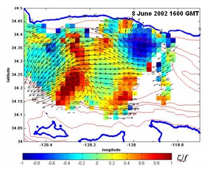
Figure 2. Surface circulation in the western Santa
Barbara Channel on 8 June 2002 at 1600 GMT. Dark blue area of
clockwise rotating arrows indicates location of small nearshore eddy
off of Coal Oil Point, CA. These eddies transport cold, nutrient
rich waters from offshore onto the continental shelf. Color scale
indicates rotation rate compared with the earth’s rotation rate.
Red areas indicate counter-clockwise rotation and blue areas indicate
clockwise rotation. Arrow at lower right indicates flow speed of
0.3 m s-1.
3. Comparisons between Lagrangian drifters and HF
radars
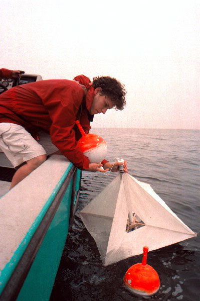 We are also collaborating with Dr. Carter Ohlmann
in a comparative study to determine how small scale spatial variability
affects the accuracy of HF radar-derived current vectors. Our
experimental approach is to repeatedly deploy patterns of drifters in
selected radar coverage cells. In situ surface current vectors
are computed from sequential drifter positions and compared with
simultaneous surface current vectors obtained from the radars.
Results from our continuing analysis indicate that differences between
the drifter and radar velocity vectors are smallest when small scale
spatial variance in the drifter derived velocities is smallest.
This suggests that unresolved small scale velocity features are
important in determining the accuracy of HF radar-derived
currents. This work will progress more rapidly when Dr. Ohlmann
returns from his year-long sabbatical at Scripps. This MMS grant
also served as “seed funding” for a successful NSF grant which will
allow us to expand the scope of this aspect of our research. We are also collaborating with Dr. Carter Ohlmann
in a comparative study to determine how small scale spatial variability
affects the accuracy of HF radar-derived current vectors. Our
experimental approach is to repeatedly deploy patterns of drifters in
selected radar coverage cells. In situ surface current vectors
are computed from sequential drifter positions and compared with
simultaneous surface current vectors obtained from the radars.
Results from our continuing analysis indicate that differences between
the drifter and radar velocity vectors are smallest when small scale
spatial variance in the drifter derived velocities is smallest.
This suggests that unresolved small scale velocity features are
important in determining the accuracy of HF radar-derived
currents. This work will progress more rapidly when Dr. Ohlmann
returns from his year-long sabbatical at Scripps. This MMS grant
also served as “seed funding” for a successful NSF grant which will
allow us to expand the scope of this aspect of our research.
4. Larval fish recruitment
and oceanographic observations
We currently have two radars deployed in the eastern
Santa Barbara Channel. A private landowner in Summerland
allowed us to erect a radar site on his coastal property for the period
1 May – 1 September 2004. This time period spanned the peak
recruitment time for bocaccio, an important rock fish species which
settles on oil production platforms. This site, along with our site at
Reliant Energy’s Mandalay generating station, provided good coverage
over much of the eastern Channel, including coverage over all of the
oil production platforms in the area.
Data from the Mandalay and Summerland sites will be used
to examine surface circulation features in the area. Inspection
of current patterns to date reveals the presence of small scale eddies
nearshore. This indicates that features we observed previously in
the western Channel may important general features of the nearshore
current field.
Our HF radar current data in the eastern channel will
complement in situ observations now being obtained on oil production
platforms Gina and Gail. Instrumentation now deployed on the
platforms include acoustic Dopper current profilers (ADCP’s),
conductivity-temperature-depth (CTD) sensors, and
thermistors. Data from these instruments will be used to
interpret data from twice-per-week SCUBA surveys to determine rates of
settlement of rockfish species on these two platforms (research
supported by MMS; principal investigator is Dr. Milton Love, of the
UCSB Marine Science Institute). Our working hypothesis is that
settlement of pelagic juvenile rockfish is related to identifiable
near-surface current patterns. Our research group is working
closely with Milton Love’s group in this research.
2. Status of the HF radar array
We are currently operating four HF radars in the Santa
Barbara Channel at the following locations: 1) Summerland; 2) Refugio
State Beach; 3) Coal Oil Point; and 4) Mandalay generating station near
Oxnard. We are also maintaining a fifth site near Pt. Sal on
Vandenberg Air Force Base. This site is not presently in
operation because we moved its electronics boxes to other sites.
However, its antennas, housing, and other equipment have been left in
place in anticipation of the site being used in the future Southern
California Coastal Current Observing System. Coverage from these
radar sites now spans the Santa Barbara Channel and extends
approximately from Gaviota to the eastern channel entrance.
** Click
here
for Final Report
|
[homepage]
|
[overview]
|
[researchers]
| [students
& staff]
|
[research] | [download reports]
|
|